Puyuhuapi to Puerto Natales, Chile

18 - 20 Feb 2006

Glacier country in the far south


Logbook index At first page Next page

This was the first day in southern Chile that we hit bad weather. It was also the first (and only) time on our trip that we had to change our destination because of weather. But we had been told to expect this in this region due to the westerly winds that brought a lot of humidity with them. The other side of the Andes in Argentina is sheltered from the worst of the weather and that is the route most VFR pilots take. But, while in Chile, we wanted to stay in Chile and fly low through the beautiful Patagonian fjords to a landing strip at the glacier of Laguna San Rafael, apparently the region’s most impressive attraction. It had been raining hard all night, but the IR satellite map and tafs of Balmaceda, Puerto Natales and Punta Arenas looked pretty good. Termas Puyahuapi does not normally provide internet access for guests, but the hotel management was kind enough to let us use their computer.
We were doing fine at 3500 feet or so until just 10 nautical miles north of Laguna San Rafael, where we got stopped by heavy rain. A local pilot from Puerto Aysen who departed Puyuhuapi for Laguna San Rafael 10 minutes after us with 6 British tourists had to abandon the idea of landing in Laguna San Rafael as well.
We had to keep clear of the clouds to avoid icing, so backtracked a bit to find a break in them to climb on top at FL135 (13,500 ft above sea level). We were too far from Puerto Montt to contact Operations by VHF radio so used the satellite phone to change our destination to Villa O´Higgins, the southernmost village that can be reached by road on the Carretera Austral.
Well, that did not work either as hardly any VFR holes were found in the solid cloud cover, so we changed destination again to Puerto Natales (with an IFR approach into Punta Arenas as back-up). To keep on top of the clouds and icing, we had to go up to FL155 and later FL175. The plane won’t go much higher than that! It was good that we had plenty of oxygen on board. Winds were 290 degrees at 80 knots, so a 30 degree crab was needed to stay on track south.
Angela was praying that there would be some holes in the clouds to allow us to make the visual approach to Puerto Natales. For one thing, she was anxious to get on the ground, and, for another, it would be a long drive from Punta Arenas to the big attraction Parque Nacional Torres del Paine where she had managed with great difficulty to book accommodation before we’d even left Geneva. Well, her prayers were answered! Puerto Natales was bathed in pristine clear sunlight as we made the approach. On the other hand, it was too turbulent to doing any filming. Winds were 300 degrees at 33 knots when landing on runway 28, and a heavy rain shower arrived just after us.
This was the second worrying flight of the trip – the first being the south Atlantic crossing – so I suppose that’s not bad going!


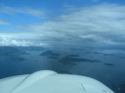
Heading from Puyuhuapi to Laguna San Rafael

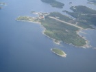
Puerto Aguirre island with its airstrip near Puerto Aysen. Shortly before the weather deteriorated.

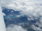
Having given up on Laguna San Rafael, one of the few gaps in the clouds near Caleta Tortel as we flew on top

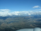
At last the clouds dispersed, allowing us to make a visual approach to Puerto Natales

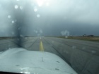
The first drops of rain were already falling as we landed in Puerto Natales with the storm at the other end of the runway.

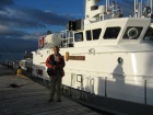
Before boarding the 21 de Mayo boat for a tour through the Seno Última Esperanza (Last Hope Sound)

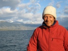
This was summer in the far south, but nevertheless, we had to don our warmest clothes against the chilly winds

Spot the rainbow!

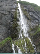
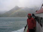
Waterfall on the way to Balmaceda Glacier

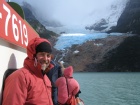
'Thanks' to global warming, the Balmaceda glacier no longer extends down to the sea

JAlbum 6.2 Copyright: Angela & Flemming PEDERSEN