
|
Maroochydore - Lord Howe Island 27 January |
After a good night's sleep, Kaye prepared an excellent cooked breakfast for us while Flemming and Gary checked the weather forecast for Lord Howe. Lord Howe is a notoriously windy island. The landing strip has high hills to either side of it which can cause severe turbulence: there is a 400 foot hill immediately to the north and 800 foot and a 3000 foot hills to the south. If there is a strong gusty crosswind, it can sometimes be too dangerous to land there due to severe to extreme turbulence. Quite similar in many respects to the Vagar airport in the Faeroe Islands in the North Atlantic in terms of low level turbulence and a long way to an alternate. At Lady Elliot Island we had a long chat with our diving boat driver, Damian Fitzgerald, who used to be an airline pilot. He had frequently flown King Airs into Lord Howe, and he gave us a very useful briefing about the conditions. Gary Burns had also often flown into Lord Howe. According to the actual weather, the wind was well aligned with the runway (90 degrees 20 knots gusting to 35), but from noon (0200Z) the wind was forecast to turn to 150 degrees at 30 knots, gusting to 42 knots which would probably cause severe turbulence as the runway axis is 100 degrees (runway 10). Gary said that the winds often took longer to change than forecast, so we decided to go for it. We took off with plenty of fuel to allow us to return to our alternate on the Australian coast, Coffs Harbour. Every half hour we called Flightwatch for the latest actual weather for Lord Howe Island. For the first hour, we followed the coast south to Coolangatta before heading out over the Tasman Sea. The wind was strong, but stayed close to the runway axis which was promising. We said a provisional farewell to the Australian mainland, hoping that we would not have to retrace our steps. Out over the Tasman ocean we quickly lost VHF radio contact, but had perfect HF communications with Brisbane Radio. HF is compulsory for flights to Lord Howe Island. They shared the concern for the surface wind with us, so without Flemming having to ask for it, the friendly lady on Brisbane Radio HF (short-wave) gave us an update on Lord Howe weather every half hour. There is an automated weather station on the island which produced reports every half an hour. As it turned out, Gary's predictions were right. The airport surface wind decided to cooperate to a reasonable extent. Aloft at 9000 feet there was a 20-knot headwind most of the way which increased our flight time from 3 hours 10 minutes to 3 hours 45 minutes. As we came into land, the winds were 20 knots gusting to 35, but the direction - at 090 degrees - was still practically aligned with the runway. Even so, I personally found the approach quite turbulent enough, thank you! I felt quite emotional with relief as we finally touched down safely, and had to admire Flemming's expertise. According to him, though, it wasn't difficult at all! In spite of the turbulence, I had been able to appreciate the stunning beauty of the island with its hills, abundant trees, green meadows, golden beaches and lagoon filled with coral reefs. I would say Lord Howe rivals with Aqaba, Jordan for the prize of 'Most beautiful and dramatic approach' of our trip so far. Pity we could only spend two nights there. There is a large welcome committee waiting for us in Auckland, so we would be unpopular if we postponed our arrival. There was no one at Lord Howe airport and there are no mobile phone services on the island. We cancelled IFR and closed the flight plan with Brisbane on HF. I suppose small population of 380 doesn't justify the installation of an antenna. Fortunately, though, there was a pay phone. We called the telephone number of the lodge where we would be staying and only got the answerphone. I left a message on it, but we had no way of knowing when the manager would return to receive it. I checked the phone book for a taxi service without success. Then, I remembered the name of another, more expensive lodge we had been told about and called them. The manager of 'Pine Trees' confirmed that there was no taxi service on the island but she would come and pick us up herself. She arrived five minutes later and we jumped aboard. We hadn't gone far along the road before we met Barbara, the manager of our lodge, the Broken Banyan. I apologised for the inconvenience as the Pine Trees manager good-naturedly helped us transfer our luggage to Barbara's car. Barbara gave us a guided tour of the small island before taking us to the lodge. We discovered that there was no restaurant at our lodge, and several of the other lodges only catered for their own guests, but Barbara booked us into restaurants for both the evenings of our stay. We staved off our hunger until dinner time with beers and peanuts at the island's only bar called Blue Peters. It was Sunday and they were closing early, but we were able to place our orders just in time. There is no car hire on the island for an obvious reason. The island is so small that one can get about easily on a bike. The next morning we hired our bikes for the day and peddled off in search of the customs officer and fuel guy whom we would need early the next day. It was Monday, but a national holiday, so we thought the most likely place to find them would be at the Beach Carnival near the Blue Peters bar. We had been told this would be the main activity of the day for most of the islanders. There was to be a barbecue and swimming races for the children. Of course, with such a small population everyone knows everyone else, so all we had to do was ask someone to direct us to John Garrett, the customs officer. He was there, sure enough, and he promised to be at the airport the following morning at 7 a.m. The fuel guy, Gawe Wilson, wasn't at the Carnival because, someone said, he'd gone to the airport to refuel someone's plane. So we peddled off to the airport but he wasn't there. We had his phone number, though, so Flemming called his wife who said to come back at 1 p.m. when he would be there to refuel the commercial airline that departed each day at 1.30 p.m. Meanwhile, we went on a nearby walk to view some masked boobies at Muttonbird Point and then went for a swim from one of the island's beautiful beaches. Although the fuel man was at the airport at 1 p.m., he was too busy with the airline to refuel ours until almost 2 p.m. Flemming and I had booked a snorkelling trip for 2.30 p.m. so it was a mad dash to get to the boat in time. But we just made it, and it was well worth it. They took us to three different spots in the lagoon and we saw a huge quantity and variety of fish, as well as the most colourful coral I have ever seen. Lord Howe Island a wonderfully pretty and unspoiled island in the middle of the huge Tasman sea, and is surrounded by the southernmost coral reef anywhere on earth. Worth a visit! Before returning to the Broken Banyan, we explored the western end of the island where we found some pieces of an unfortunate Catalina seaplane that crashed there before the airstrip was built in 1974. We finished the day with a gourmet meal at "Trader Nick's" restaurant. This was to be Ray's last dinner of the trip with us before the last leg to Auckland. After three months of travelling together we were all in a cheerful mood. |
Click on image to
enlarge, click browser back to return
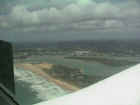
Airborne at Maroochydore, Queensland, bound for Lord Howe |
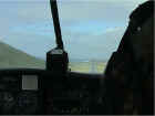 On short final for runway 10 at Lord Howe Island. Note the 400 foot hill north of the runway on the left, and the little 200 foot hill in the ocean straight ahead. |
|
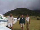 Safe arrival at Lord Howe. Flemming, Ray and Angela in front of the 800 foot hill south of the runway, that creates hell when the wind is SE or S. |
|
 Australia Day carnival at the Lagoon beach at Lord Howe. Looking for John Garrett and Gawe Wilson. |
|
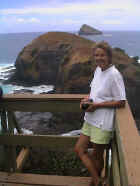 Angela admiring the view of Muttonbird point. |
|
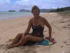 Angela on the deserted and unspoilt beach on the lagoon side of the island. Blackburn island to the left. |