

|
San Cristóbal - Chichén Itzá 11 April |
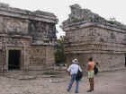
There was a thick layer of low cloud hanging over the airport and vicinity when we arrived. The airport officials were anxious not to make any booboos with the President's arrival. Apart from telling us to move our plane before 8 a.m., they kept running about like headless chickens and we had to wait until the President had arrived and left the airport before the airport comandante would stamp and sign our flight plan. To add insult to injury, the captain of the President's jet hadn't even used the space that we had vacated and plonked his Learjet right next to ours! And if that weren't enough, the flight plan with all its rubber stamps and signatures - as far as the airport was concerned - only served as permission for us to depart. The reported ceiling was 1000 feet, but a hill at 8400 feet elevation immediately north of the airport (600 feet above airport ) was in the clouds. May be they cheated with the weather report so that the President's jet could legally make the approach as the MDA for the VOR/DME runway 11 is 8740 feet, 1000 feet above the airport elevation. Fortunately there is an instrument departure or we would have had to wait several hours for the clouds to lift. On the other hand, until we could make radio contact with the controllers, no one except the comandante of the airport would be aware of our proposed flight. Flemming requested a clearance from the local AFIS frequency, but was told to just depart, file the flight plan in the air by radio and request clearance from nearby Tuxtla approach. After we had lined up for takeoff on runway 11, there was some incoming traffic announced in Spanish on the local AFIS frequency and due to arrive just 4 minutes after our departure, so we departed into the overcast skies with embedded mountains after we were told that the incoming traffic was established on final for runway 11at San Cristóbal - the opposite side of our departure procedure. Very poor or rather non-existing coordation by the AFIS controller. Scary, scary... I overheard the pilot of the other plane inform San Cristóbal tower in Spanish that he was in clear skies at 12,000 feet, so at least that was encouraging! We were reasonably light by this time, not having refuelled since Toluca, so it wasn't long before we had climbed the some 2,700 feet above the runway elevation to break out of the clouds at 10,500 feet. Only then were we able to establish radio contact with Tuxtla approach, file the flight plan and get our IFR clearance. Our original plan was to fly to Palenque (the Mayan city in the jungle), some 40 minutes away. But in view of the weather and the fact that Palenque doesn't have an instrument approach or departure procedure, we had decided to file IFR for Chichén Itzá instead. As it happened, there were some holes in the clouds near Palenque as we flew past it at 13,000 feet, but there was no guarantee of a safe VFR arrival and we were not sure whether a visual departure would be possible the following morning,, we still pushed on to Chichén Itzá. We landed at the brand new Chichén Itzá airport after a total flight time of 2 hours 41 minutes. Chichén Itzá was hot after the cool mountain air of San Cristóbal. I lounged around the hotel swimming pool after lunch while Flemming did some work on the computer. We purposely waited until later in the afternoon to visit the Mayan ruins - to avoid the worst of the heat as well as the hordes of tourists that invade the place every day from nearby Cancún. Hiring a guide is not exactly cheap - about US$ 40 for 2 hours - but it is well worth it as it saves having to look up everything in the guide book as one walks around. What's more, they know how to sift out the major points of interest. Our guide, Gabriel, also pointed out an iguana, neatly camouflaged against its background. It was motionless, no doubt thinking that it was invisible to our eyes. Then I saw some colourful birds with blue bellies and unusual tails with twin prongs connecting the body to the tail feathers. Gabriel said they are called clock birds since the tail resembles a pendulum. There are several species of birds at the site and apparently some people visit it solely to bird watch! We returned to the site in the evening for the light and sound show. A thunderstorm timed itself just right to enhance the lighting effects and there was a dramatic crash of thunder for the finale! Fortunately, the worst of the storm was a few kilometres away and we only got a few drops of rain.
|
Click on image to
enlarge, click browser back to return
|
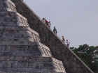 The western staircase of El Castillo. During the spring and autumn equinoxes, light and shadow form a series of triangles on the northern staircase that mimic the creep of a serpent |
|
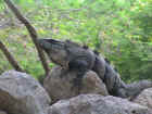 The iguana |
|
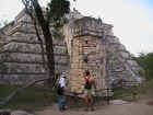 Our guide and Angela inspecting sculptures of the rain god |
|
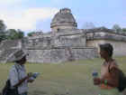 The observatory |
|
 Edificio de las Monjas (Nunnery) |